
Maximize airspace benefits
Airspace Efficiency from GE Aerospace, Software, empowers airlines with flight path design and maintenance services, airspace analytics, and expert consulting to maximize airspace benefits.

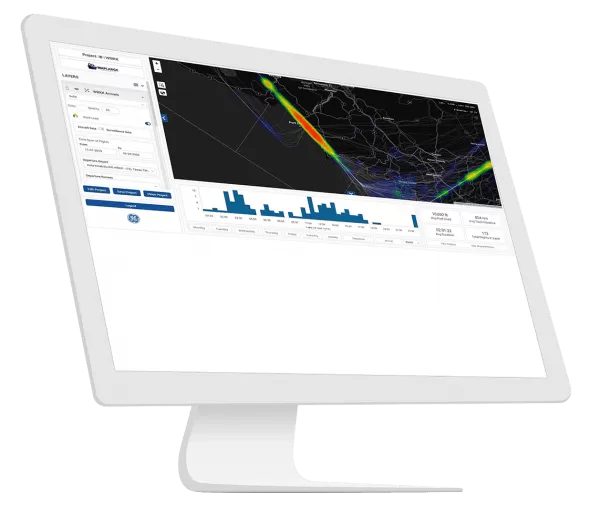
Democratize your flight data
With GE’s agile airspace analysis web application presenting data in a simple and intuitive format, airlines, airports, and other stakeholders make decisions collaboratively.
Answer complex “what if” questions at the click of a button, make rapid, high-quality decisions, and foster collaboration. When coupled with flight path design services and airspace consulting services, meaningful changes to improve airspace operations happen. Whether you’re an airline, airport, or ANSP, Airspace Efficiency democratizes a world of data to identify opportunities, drive change, and monitor progress toward more efficient, sustainable, resilient, and safe operations.
Answer complex “what if” questions at the click of a button, make rapid, high-quality decisions, and foster collaboration. When coupled with flight path design services and airspace consulting services, meaningful changes to improve airspace operations happen. Whether you’re an airline, airport, or ANSP, Airspace Efficiency democratizes a world of data to identify opportunities, drive change, and monitor progress toward more efficient, sustainable, resilient, and safe operations.
Aviation Software from GE Aerospace


Expand your network of destinations
Access terrain-challenged airports
Navigation Services enables the deployment of high-performance PBN flight paths at airports with insufficient ground-based navigation infrastructure to accommodate safe, efficient, all-weather operations. PBN infrastructure is space-based meaning it is less prone to the service disruption from the impacts of severe weather and natural disasters that we see with typical ground-based navigation systems.
With improved approach minimal in terrain-challenged airports, airlines can create flight paths to address their unique needs, and gain competitive advantages, while increasing safety and operational reliability while reducing weather-related cancellations and diversions.
- Tailor instrument flight paths to specific aircraft performance capabilities to maximize benefits at extreme airports.
- Retain commercial advantages over your competition through bespoke solutions for your exclusive use
- Gain insights for generation of route qualifications for new/challenging destination/city-pairs
Identify inefficiencies in an airspace
Airspace Insight helps identify and quantify airspace inefficiencies to reduce overall flight time, fuel burn, and carbon emissions. It is estimated that a typical flight emits 900 to 1,000 kg of excess carbon per flight due to inefficient airspace design and air traffic control practices*. Airspace Insight is the first tool of its kind enabling a collaborative approach between all necessary stakeholders (Air Traffic Control (ATC), airlines, airports, airspace designers, and communities) to not only identify inefficiencies in an airspace, but also to recognize unnecessary flight paths over environmentally sensitive areas, helping reduce the impact of noise and pollution.
- Enable stakeholder collaboration on airspace sustainability improvements
- Access visualizations and metrics to help ATC, airlines, and airports find efficiencies to increase sustainability
- Quickly and easily answer complex "what if" questions
- Quantify carbon benefits associated with multiple potential airspace solutions
- Access ongoing initiative progress tracking to drive common objectives

Reduce time and fuel consumed in airport traffic areas
- Compare competing airline operations
- Understand relative efficiency of similar airspaces to drive improvements
- See actual airspace behavior v. assumed (or actual v. promised)
- Quantify the impact of airspace and procedural changes—hold stakeholders accountable
- Provide input to pilot training to include quantification of benefit
- Reduce operating costs related to fuel, time, diversions, and cancellations
- Eliminate data silos, democratize data, and integrate multiple data sources
- With more accurate and efficient flight paths airlines can carry more passengers and cargo further and increase passenger satisfaction by increasing on-time performance and avoiding diversions and diversions
- Increase the departure weight for increased fuel and passenger/cargo loading
Reduce safety risk with modern flight path design and flight path maintenance services
Navigation Services helps reduce safety risk with modern flight path design and flight path maintenance services.